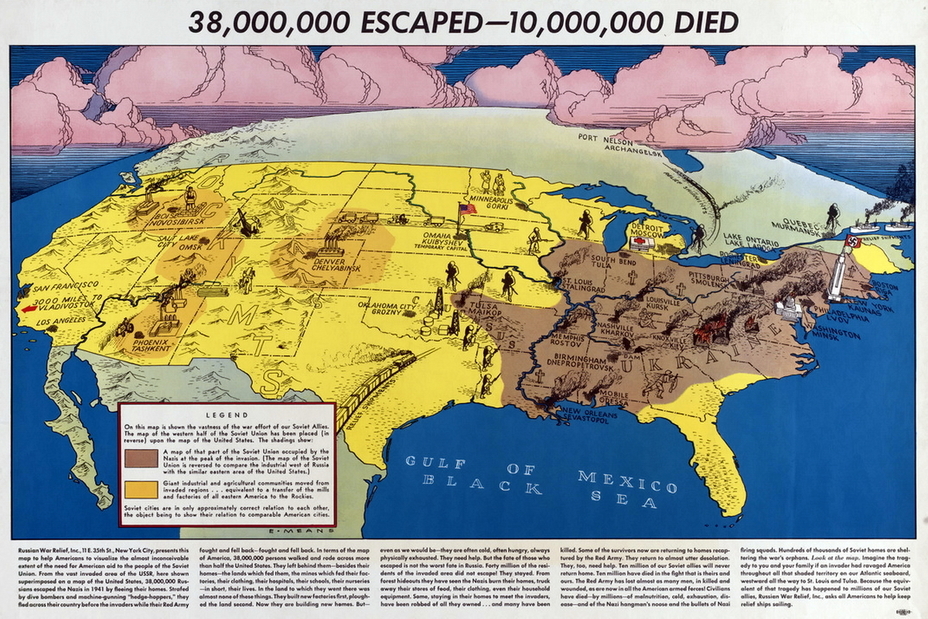
A human being by nature perceives the information that he sees with his own eyes or experiences personally as the closest and the most compelling. This peculiarity was used by the Russian War Relief (RWR) Society, created in the USA in the summer of 1941, which decided to convey to every American the approximate scale of the war raging on the opposite side of the globe in some strange country.
In early 1943, RWR issued a very illustrative poster entitled «38 Million Escaped — 10 Million Died," created by artist Elliot Anderson. It turned out that it is quite possible to overlay the mirrored map of the USSR on the map of the United States and the adjacent regions of Canada and Mexico — both states had a significant uneven distribution of population and industry, and the developed European part of the Soviet Union became an analogue of the east coast of the United States. The American West depicted uninhabited Siberia, and the Pacific states depicted the Soviet Far East.

The picture clearly shows Washington-Minsk with a burning Capitol, fallen under the enemy onslaught; a giant flag with the swastika flies over the Empire State Building in New York-Kaunas. Nearby Philadelphia-Lviv, Boston-Riga, Pittsburgh-Smolensk and for some reason little Knoxville-Kyiv are painted over in brown. Above, on the border with Canada, Rochester-Leningrad is holding out near Ontario-Ladoga, and to the left of it Detroit-Moscow is defending, to the south of which South Bend fell for some reason — it is associated with Tula, which, as you know, the Germans did not take.
Farther south, on the coast of either the Gulf of Mexico or the Black Sea, New Orleans-Sevastopol and Mobile-Odessa have fallen, and Birmingham-Dnepropetrovsk, Nashville-Kharkov, Louisville-Kursk and Memphis-Rostov are all burning in the depths of the country.
The front is situated along the great Russian Mississippi River, where St. Louis-Stalingrad is fighting, and to the south, a serious confrontation can be seen in the Oklahoma-Caucasus oil fields: battles are taking place in the areas of Tulsa-Maikop and Oklahoma-City-Grozny. The capital has been moved to Omaha-Kuibyshev, Minneapolis-Gorky is receiving refugees nearby. Industry has been evacuated to the American West: to Denver-Chelyabinsk and beyond the Rocky Mountains, which are also the Ural Mountains. There we can see working factories of Salt Lake City-Omsk, Phoenix-Tashkent and Boise-Novosibirsk.
Lend-lease from unknown allies arrives at the ports of San Francisco-Vladivostok in the Far West, and Canadian Port-Nelson-Arkhangelsk and Quebec-Murmansk help from the north. On the southern route, Mexico plays the role of Iran.
The poster is accompanied by explanatory text telling about the course of the war and calling for help to the Russian allies.


